
Maps
Maps will be 1:10,000, 5 meter contours for most courses. White, yellow, and brown courses at McFarlan and Miami Whitewater (Fri and Sat only) will be printed at 1:7500. All Sunday sprint courses are printed at 1:3000.
Courses
All standard USA courses and classes will be offered.
Control descriptions
Control descriptions are printed on your map. Loose description sheets may be picked up when you enter the call-up area 2-3 minutes before your start. Descriptions for white and yellow courses are in English only. Descriptions for orange course and above are in IOF symbols only (ISCD2004).
Control Markers
Control markers will be IOF standard orange and white flag. Control markers will have a blue stripe, either diagonal or vertical.
Course Length (km) and Climb (m) Table (subject to change)
| Course | Classes | Friday – Middle Bicentennial Park | Saturday – Long Miami-Whitewater | Sunday – Sprint NKU |
| Course setter | Mike Minium | Mike Minium | Ben Hart | |
| 1 White | F-10, F-12, F white, M-10, M-12, M white, Group white | |||
| 2 Yellow | F-14, F yellow, M-14, M yellow, Group yellow | |||
| 3 Orange | F-16, F orange, M-16, M orange, Group orange | |||
| 4 Brown A | F65+, F70+, F75+, F brown, M brown, all 80+ classes | |||
| 5 Brown B | F-18, F55+, F60+, M65+, M70+ M 75+ | |||
| 6 Green A | F35+, F40+, F45+, F50+, F green, M green | |||
| 7 Green B | F-20, M-18, M50+, M55+, M60+ | |||
| 8 Red | F-21+, M-20, M35+, M40+, M45+, M red | |||
| 9 Blue | M-21+ |
Start Procedures
- Clear and check your SI card when you arrive in the start area.
- You will be called up 3 minutes before your scheduled start.
- 2 minutes before your start, you will move forward and may pick up loose control descriptions.
- 1 minute before your start, you will move forward to the map line. You may mark your name / number on the back of the map. Do not look at your map. You may ask the starter to check that it is the correct course.
- When the beeper sounds, you punch “start” and pick up your map.
- There may be a short streamered run to the start triangle shown on your map (to be determined). You must run to the triangle. There is a flag but no punch at this point. At this point you may begin navigating to your first control.
Drinking Water on Course
There will be at least one control with drinking water on middle and long courses of orange length and above. Please use the cups provided and dispose of them in the bag or bin provided.
Time Limits
Time limit will be 2 hours for Middle Distance (Friday), 3 hours for Long Distance (Saturday), and 1 hour for Sprint Distance (Sunday)
Friday – McFarlan Woods
Middle Distance, Most maps will be 1:10,000. White, yellow and brown will be 1:7500.
- Parking near registration and finish
- Restrooms near parking, registration and finish
- Walk to the start less than 500 meters
Terrain
McFarlan Woods features steep ridge and valley terrain, with some areas of intricate depressions (karst). There is an extensive network of horse and hiking trails. The area is bisected by a large stream and smaller tributaries which can generally be crossed with dry feet, but can become rushing torrents during heavy rain. McFarlan and Mt Airy have more exposed rock than most Cincinnati area parks. Although there are few rocks and cliffs large enough to map, there are areas where you will find rocky footing (at least relative to other OCIN venues).
There is a chance of meeting horses and riders. Please show them courtesy.
Mapper’s Notes
Special Symbols
Rootstocks are shown with a brown X. Some of the older ones are very deteriorated. I don’t guarantee that I have found every new roostock that others would deem worthy of mapping.
A blue O, generally along streams, represents a sewer cover. Some of these are very visible, rising 2 meters above the stream and some are surrounded by shiny metal and concrete. Others are nearly flush with the ground and nearly impossible to see. On the map, they look the same, regardless of height. Recent sewer work has moved or buried some of these. Look for an update about this symbol, closer to the event date.
A green O is a distinct single tree.
There are a few black X’s on the map, which may be signs, picnic tables (only in the forest, not in picnic areas), miscellaneous man-made objects, or a couple small deer-exclusion fenced areas.
There is one black O on the map, which is a campfire circle.
There are a few blue X’s near parking areas which may be fire hydrants or water pumps.
Saturday – Miami-Whitewater
Long Distance, Most maps will be 1:10,000. White, yellow, and brown courses are printed at 1:7500.
- Parking details tba, 50-500 m from finish and registration)
- Restrooms details tbs
- Walk to the start will be about 2 km on road and trail. Please keep to the flagged side of the road for safety reasons.
Mapper’s Notes
Keep in mind that this map was originally made for use at a scale of 1:15,000. Vegetation has changed quite a bit over the years, and while updating has been done, you may find some variances between the map and reality. Also, in recent years, there has been a trend to make maps increasingly more detailed, for use at smaller scales. So the map may not contain quite as much precise detail as you would expect on a newer map. On the other hand, in the eroded “Badlands” areas, you may be squinting to read the intricate contour detail
Southwest Ohio does not have many boulders. There are no mapped boulders in Miami-Whitewater; and the very few surface rocks are nowhere close to a mappable size, even for southwest Ohio.
The map was originally made by the late Russian mappers George Kuntsevitch and Marat Gizatulin. They did not use as much green as is typically seen on more recent orienteering maps, especially most other OCIN maps. Much of the mapped area is very open, but you may sometimes feel like a particular area should be mapped the next darker shade of green. Areas of medium and dark green will definitely slow you down.
Otherwise, we think the Miami Whitewater map has aged very well, and is a fair representation of the terrain. Extensive updating has been done in 2016, and again this year.
Rootstocks: We found that many of the rootstocks on the old map were either very small and deteriorated or gone completely. So we removed any rootstock that was not visited and verified to still be there. We also added a few new rootstocks, if they were substantially over a meter in height, solid looking, and clearly distinguishable from surrounding deadfall and debris. We have not been everywhere, and we were quite selective about adding only substantial rootstocks, so there are many other rootstocks in the forest which are not on the map. Rootstocks are shown with a brown X.
Hunter’s Stands: Hunter’s tree stands are not mapped. All hunting stands are supposed to be removed by March 1, but historically, some have been left much longer.
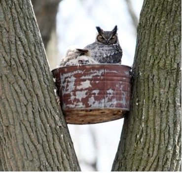
Nesting Platforms: A black T, the symbol for small tower, has been used to indicate platforms that were put in many years ago as nesting platforms for Great Horned Owls. These are a metal drum, high in a tree (at least 6 to 10 meters up). They are easily missed, but useful for relocating if you happen to see one. Some have rusted over the years and the bottoms have fallen out. However, a few are still active owl nests. Those with resident owls have been marked with a roughly circular area of purple out-of-bounds striping. Please respect this out of bounds area for two important reasons. First, disturbing the parents may endanger the young chicks, especially if the weather is cold or wet. Second, Great Horned Owls have been known to aggressively protect their nests and young. The researcher who erected these platforms later lost an eye to an owl attack, while monitoring nests.
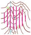
around nesting platform
Course Setter’s Notes
You will see survey flagging tape of various colors. If you see pink or orange pin flags in the ground, try to avoid running through these environmental study areas. If yellow “caution” tape blocks an area, please respect and go around (we’ve marked a couple plots of sensitive wildflowers, and we may mark a perimeter around a couple of the owl nests or other hazards). Otherwise, any streamer tape you see means nothing in relation to your course or control locations. You’ll especially see lots of orange striped tapes – these marked safety areas around deer hunter’s stands, but hunting ended in early February.
You may also see yellow and black “area closed” signs, which you can ignore. If you get close enough to read the fine print, you’ll see that they list dates of Sept 20 – Feb 10, coinciding with deer hunting season.
We’ve also found a couple free-hanging 4 inch (10 cm) mini-control orienteering markers that presumably have been left there by a local ROTC unit or scouts. They are not on your course; all of our control markers are full sized with an SI timing unit.
Park boundaries are sporadically marked with dull orange, 1 meter tall plastic (Carsonite) posts. These are surprisingly hard to see from the side, but may help you identify a boundary. Additionally, there is a slight chance that you might see one or two at seemingly random places inside the park where there was a boundary many years ago before additional land was purchased.
There is a chance of meeting horses and riders. Please show them courtesy.
Sunday – Northern Kentucky University
Sprint Distance, Maps will be 1:3,000.
- Parking in Lots K and L. Be sure to follow directions to avoid entering embargoed area.
- Restrooms indoors at Campus Recreation Center. Showers may be purchased.
- Walk to the start will be 50 – 300 meters.